
NASA Photographs Melting Antarctica In Most Intense Heat Wave Recorded

Image via Shutterstock
Antarctica, the coldest continent in the world, suffered its highest-recorded temperature ever on 6 February 2020. Temperatures on the northern tip of the Antarctic Peninsula climbed to 64.9°F, about the same temperature in Los Angeles that day.
NASA’s Earth Observatory satellite captured evidence of the worrying predicament, which saw “widespread melting” on surrounding glaciers.
Two images shared by the space agency show the rapid melting of ice and snow in Eagle Island. The first, taken on 4 February, reveals the area to still be covered in snow. However, on 13 February, it is dampened with blue melt ponds shows exposed ground.
Mauri Pelto, a glaciologist from Nichols College in Massachusetts, related that this was the first time he had witnessed melt ponds “develop this quickly in Antarctica.”
Pelto said that the ice caps were melting so quickly because they had sustained temperatures much higher than freezing. It was only until the 21st century that the continent began being subjected to perpetual warmth, though the pattern has become more consistent in recent years.
“If you think about this one event in February, it isn’t that significant,” Pelto added. “It’s more significant that these events are coming more frequently.”
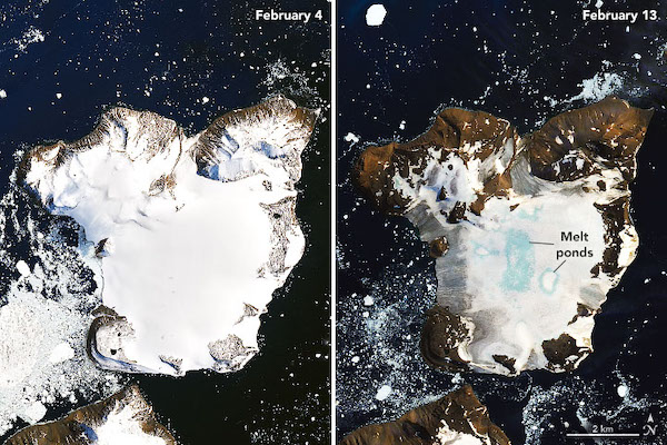
Satellite image of Easter Island on 4 February (left) VS image of Easter Island on 13 February. Image by Joshua Stevens via NASA Earth Observatory, using Landsat data from US Geological Survey and GEOS-5 findings from the Global Modeling and Assimilation Office at NASA GSFC
[via CNET, images via various sources]
Also check out these recent news


