Seals Donning ‘Hats’ Help Scientists Navigate Hard-To-Reach Parts of Antarctica
The continental shelves of Antarctica—regions submerged under shallow waters—are among the most fertile areas in the world’s oceans, thanks to the rich exchanges between ocean, sea ice, and ice shelf that give rise to nutrients forming in those parts. Discovering more about these waters is challenging and dangerous, however, as the ice on the shore makes them inaccessible by ship.
So instead of using boats or drones, oceanographers from the National Institute of Polar Research (NIPR) in Japan turned to Antarctica’s natural navigators—seals—to help gather data from the hard-to-reach continental shelves. The project, which took place in 2017, was recently outlined in the Limnology and Oceanography scientific journal.
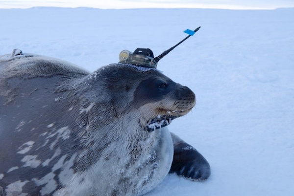
Between March and September of that year, eight Weddell seals had Rubik’s Cube-sized CTD-Satellite Relay Data Loggers, weighing about a pound each, glued to their heads. The sensors collected data on conductivity, temperature, and depth, and sent the findings to the scientists via satellite relay.
From the seals’ diving “hats,” the team learned that the subsurface of the continental shelves would turn up warm and low-salinity water in the fall, and that warm water would get deeper as the season progressed. Autumnal winds also potentially swept more prey into the Antarctic coastal marine ecosystem, bringing forth “positive effects on the seals’ foraging behavior.”
“The investigation showed that seals with oceanographic sensors attached to them could be powerful tools to explore oceanographic and ecological conditions across a very wide range of Antarctic continental shelves covered with landfast ice,” describes a news release newly published on EurekAlert. “Ultimately, the researchers hope to be able to use these data to predict how the Antarctic coastal marine ecosystem is responding to the ongoing rapid changes in Antarctic sea ice.”
[via EurekAlert and Boing Boing, cover image via Nobuo Kokubun (NIPR) / EurekAlert]


